
Flooding
View our new Floodplain Management Plan
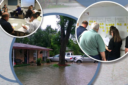
The Bryan City Council approved an updated Floodplain Management Plan on Oct. 10. This new plan is the culmination of months of work by city staff members, outside contractors, and residents of Bryan. Thanks to all Bryan residents who helped us by providing feedback over the course of the summer. Public feedback was vital to helping the planning committee identify flood risks, understand vulnerabilities, and select achievable mitigation strategies to protect from flood impacts.


Flood Hazard Awareness
Having increased knowledge and awareness of possible flooding in Bryan better prepares citizens for possible emergencies.
Bryan’s local flood hazard
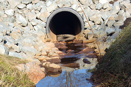
Bryan is similar to other cities located in the eastern part of Texas with mostly flat terrain and some rolling hills, significant amounts of urban impervious cover (concrete, asphalt, and homes), slow-absorbing soil, and potential for heavy rainfall from thunderstorms, tropical storms, and hurricanes all combine to form ideal conditions for flooding. Due to its humid-subtropical climate and general proximity to the Texas coast, Bryan is susceptible to large amounts of rainfall that are often too great for its infrastructure and creeks to handle. The city’s streets and thoroughfares drain into the following creek systems: Carters, Burton, Briar, Hudson, Thompson, Still, Cottonwood Branch and Turkey. These creeks then drain into either the Brazos River or the Navasota River.
- Current water level information for the Brazos River at State Highway 21 can be accessed online here.
- Current water level information for the Navasota River at Old San Antonio Road (OSR) can be accessed online here.
- For additional information on the risks of flooding and what to do in emergencies, please read our Flood Information brochure and our Floodplain and Repetitive Loss property mailing.
Importance of flood insurance
Future flooding in the Bryan area will undoubtedly occur. Predicting when and where the next flood will take place is virtually impossible. Even though your property may not be located in the floodplain, it is still possible your property may incur damage caused by flooding. Homeowners insurance does not cover flood damage; however, flood insurance backed by the National Flood Insurance Program (NFIP) is unconditionally available to all residents in Bryan. The Federal Emergency Management Agency (FEMA) has introduced a new flood insurance rating option for the NFIP to help reduce the financial burden placed on property owners whose buildings are newly mapped into a high-risk flood area. Flood insurance can be purchased from the NFIP or through your local insurance agent. Contact your property insurance agent or visit www.floodsmart.gov for more information.
Dispelling Myths about Flood Insurance
- Click on the link below to view some common myths and misconceptions about flood insurance. Dispelling Myths
Floodplain development and substantial improvement/damage requirements
All development within the floodplain is required, by City ordinance, to have development permits. Elevation Certificates are official documents prepared by Registered Professional Engineers licensed in the state of Texas or by licensed Professional Land Surveyors that provide specific elevation and flood zone information for structures located in the 100-year floodplain. Elevation certificates and development permits are on file and available at the City of Bryan Engineering Offices in the Municipal Building, 300 South Texas Avenue. Substantially damaged or improved structures require special permits and documents. Storm water management-related information on development and building standards under the City of Bryan’s Code of Ordinances may be referenced at the following link: http://www.municode.com. Navigate to the City of Bryan Code of Ordinances and select Chapter 10, “Flood Prevention and Protection”.
Property protection
In the event of a flood warning, and if time is sufficient, relocate your furniture and belongings to a higher elevation in your home. Place important documents in a dry location and preserve as much water and non-perishable food as possible. To protect property from future floods, permanent retrofitting structures, such as elevating foundations and floodproofing basements, should be considered. The City of Bryan’s Floodplain Management Ordinance requires all new or substantially improved properties to elevate the lowest finished floor to a minimum of one foot above the 100-year floodplain. Floodproofing also is an acceptable structural method for protecting a non-residential structure from flooding. Information about these and other floodproofing measures is available at the Bryan Public Library.
Helping to reduce flooding in the city
A floodplain is the normally dry area, usually low land, adjacent to a stream, river, lake, watercourse, or bayou that is inundated on a periodic basis with flood waters. Floodplains are natural features that serve to detain the stormwater from invading urbanized areas caused by overwhelmed drainage systems. Keeping the floodplains clear of adverse encroachments can help retain their beneficial functions. While the City does have a storm sewer and maintenance program, keeping all drainage systems clear at all times is almost impossible. As a citizen, you can assist by keeping the banks of ditches, streams, and creeks clear of brush and debris, and not allowing grass clippings, oil, or other contaminants in storm sewer inlets. Dumping of debris into ditches, streams, or creeks is a major cause of local drainage problems, and is a violation of the Bryan Code of Ordinances. To report a violation or a maintenance problem, please contact the City’s Municipal Services Center at 979-209-5900.
Bryan Floodplain Management Plan
On April 10, 2007 the City of Bryan adopted a Flood Mitigation Plan to create a strategy for implementing flood mitigation measures for the community. The plan identified several items for floodplain planning that the city has worked on implementing. These items include:
- Minimize losses due to flooding and achieve a balance between natural open space and improvements for drainage
- Preserve and protect unique open spaces, river corridors, drainage corridors and green spaces within the City and its Extraterritorial Jurisdiction
- Develop a network of pedestrian and bicycle ways for hiking and cycling throughout Bryan
- View the Current Floodplain Management Plan
Each year a progress report is prepared as part of the City’s Community Rating System annual recertification process and copies of the progress report are provided to the Bryan City Council and made available to the news media and the public. The intent of the report is to give a brief update on the City’s progress with respect to each of the plan objectives and goals, and to expand on the city’s future activities.
How to protect yourself and your family during a flood
- Take your family and yourself to a safe location. Don’t forget your pets; remember, they depend on you too.
- Do not use electrical appliances that may have become wet. Stay away from power lines and electrical wires.
- Do not walk through flowing water or drive through a flooded area. Ten inches of water on the roadway where water is flowing rapidly will carry away most cars and small trucks. Depth of water is hard to determine so when in doubt, play it safe and find an alternate route.
- Listen for information by tuning to local radio and TV stations. Also, be aware of the Emergency Alert System and familiarize yourself with different warning signals. The National Oceanic and Atmospheric Administration (NOAA) Weather Radio broadcasts current local weather information, watches, warnings, and forecasts 24 hours a day, and can be monitored on 162.400 mhz.
- View more preparedness information from the Brazos County Department of Emergency Management
For more specific information regarding the proximity of your structure to these areas, please consult the most current Flood Insurance Rate Maps (FIRMs). FIRMs also are located at the Bryan Public Library and at the Engineering Department located on the 1st floor of the Municipal Building, 300 S. Texas Ave. Other resources can be found at: City of Bryan Topography Map Service and Brazos County FEMA DFIRM.
What is a Floodplain?
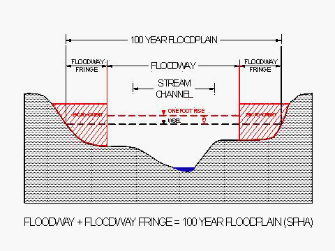
A floodplain is typically a lowland area adjoining a watercourse. At a minimum, the area is subject to a 1% or greater chance of flooding in a given year. The 100-Year Storm is not a storm that occurs once every 100 years.
A floodway is the part of a watercourse which provides most of the conveyance for a flood event. Specifically, it is the channel of a watercourse and adjacent land areas that must be reserved to discharge the base flood without cumulatively increasing the water surface more than one foot above the base flood elevation and without creating hazardous velocities.
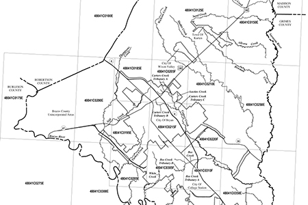
The Federal Emergency Management Agency (FEMA) has mapped the floodplains of most of the major channels in Bryan. These floodplains are shown on Federal Insurance Rate Maps (FIRM) and are the basis for flood insurance rates. These maps are located in the Engineering Department and are available for review.
Flood Zone Determinations
Citizens of Bryan, lenders, insurance agents and real estate offices can obtain flood information concerning flooding, flood maps, mandatory flood insurance purchase requirements, flood insurance requirements and inquiries and flood zone determinations; including location within floodway, historical flooding hazard area or local drainage problem areas. Just call or email us and give us a property address or legal description of the property you would like a determination for and contact information on how we can reach you. Turnaround time depends on staff workload but usually happens within 2 days.
All determinations are made using the “FEMA Flood Insurance Rate Maps for Brazos County, Texas and Incorporated Areas” with an effective date of May 9, 2014. These maps are the basis of Special Flood Hazard Area information and designate Zone A and AE areas. In the Zone AE areas, we can also provide Base Flood Elevations as well as known floodway locations. We will also cross reference more recent studies that have occurred without benefit of Letter of Map Revision to give you the most comprehensive determination possible.
We are not allowed to provide this service for parcels located outside of the Bryan City Limits. Please contact the City of College Station or the Brazos County Engineer’s Office for these areas.
A Professional Flood Determination Company, Professional Engineer or Professional Land Surveyor should be contacted to make further determinations. We also maintain records of all completed elevation certificates at our offices in the Municipal Building at 300 S. Texas Ave. Please contact us if you have any questions.
Flood Insurance Rate Maps
These maps are for use in administering the National Flood Insurance Program. They do not necessarily identify all areas subject to flooding, particularly from local drainage sources of small size, or all planimetric features outside Special Flood Hazard Areas. Areas of special flood hazard (100-year flood) include Zones A, AE, AH, AO, A99, V, and VE.
City limits shown are current as of the date of these maps. Users should contact the City of Bryan to determine if the city limits have changed subsequent to the issuance of these maps.
To access the firm map that covers your area, click on the link below. This will open an overall map of the FEMA grid area. Then click in the square your property is located within. This will bring up a more detailed map of the area surrounding your property. Then use the zoom tools to get a closer look.
Should you have any questions concerning the floodplain in your vicinity or questions on how to use the interactive map please contact us at (979) 209-5030 or Email Engineering Services.
Elevation Certificate
The Elevation Certificate is an important administrative tool of the National Flood Insurance Program (NFIP). It is to be used to provide elevation information necessary to ensure compliance with community floodplain management ordinances, to determine the proper insurance premium rate, and to support a request for a Letter of Map Amendment or Revision (LOMA or LOMR-F). The Elevation Certificate is required in order to properly rate post-FIRM buildings, which are buildings constructed after publication of the Flood Insurance Rate Map (FIRM). The Elevation Certificate is not required for pre-FIRM (prior to 11/19/1980) buildings unless the building is being rated under the optional post-FIRM flood insurance rules.
As part of the agreement for making flood insurance available in a community, the NFIP requires the community to adopt a floodplain management ordinance that specifies minimum requirements for reducing flood losses. One such requirement is for the community to obtain the elevation of the lowest floor (including basement) of all new and substantially improved buildings and maintain a record of such information. “Substantial improvement” means any reconstruction, rehabilitation, addition or other improvement to a structure, the total cost of which equals or exceeds 50 percent of the market value of the structure before the start of construction of the improvement. The Elevation Certificate provides a way for a community to comply with this requirement.
Use of this certificate does not provide a waiver of the flood insurance purchase requirement. Only a LOMA or LOMR-F from the Federal Emergency Management Agency (FEMA) can amend the FIRM and remove the Federal mandate for a lending institution to require the purchase of flood insurance. However, the lending institution has the option of requiring flood insurance even if a LOMA/LOMR-F has been issued by FEMA. The Elevation Certificate may be used to support a LOMA or LOMR-F request. Lowest floor and lowest adjacent grade elevations certified by a surveyor or engineer will be required if the certificate is used to support a LOMA or LOMR-F request.
This certificate is used only to certify building elevations. A separate certificate is required for floodproofing. Under the NFIP, non-residential buildings can be floodproofed up to or above the Base Flood Elevation (BFE). A floodproofed building is a building that has been designed and constructed to be watertight (substantially impermeable to floodwaters) below the BFE. Floodproofing of residential buildings is not permitted under the NFIP unless FEMA has granted the community an exception for residential floodproofed basements. The community must adopt standards for design and construction of floodproofed basements before FEMA will grant a basement exception. For both floodproofed non-residential buildings and residential floodproofed basements in communities that have been granted an exception by FEMA, a floodproofing certificate is required.
These certificates are prepared by Engineers, Architects or Land Surveyors registered in our State. Blank forms and instructions for completion may be found at the FEMA Elevation Certificate page.
Development of Flood Hazard Areas
A Development Permit is required when a developer wishes to build in or alter the character of property identified in the 100-year regulatory floodplain. If any proposed grading or improvements involve property in the floodway, a hydraulic flood study prepared by an engineer licensed in the State of Texas is required. The applicant’s engineer will need to submit the study and supporting hydraulic data to the City’s Engineering Department. This information will be reviewed by the Federal Emergency Management Agency (FEMA) as well as the City. The appropriate FEMA application forms and fees will also be required at the time of submission.
NOTE: A detailed study may also be required for development in areas that do not yet have a mapped floodway but have been identified as floodplain. If the proposed grading or improvements only involve property in the floodplain fringe, a development plan and permit application (with the appropriate certifications) will need to be submitted to the Engineering Department for City review and approval only. After construction, elevation certificates will be required as applicable to the project.
Requirements associated with property in the Floodplain:
- Development Permit
- Minimum Finish Floor Elevations (Elevation Certificates)
- No encroachments in floodway without study
- May require detailed study if located in a FEMA undetermined flood hazard zone
FEMA Publications on Flooding
Below are additional educational resources from the Federal Emergency Management Agency (FEMA) on how to prepare for flooding, how to protect your interests, how to reduce possible damage, floodplains, and the National Flood Insurance Program. These resources will help you understand your flood risks, and how to best address them.
- Engineering Principles and Practices for Retrofitting Flood-Prone Residential Structures
- Answers to Questions About the National Flood Insurance Program
- Elevated Residential Structures, FEMA-54 (1984)
- Costal Construction Manual, FEMA P-55 (2011)
- Mitigation of Flood and Erosion Damage to Residential Buildings in Coastal Areas, FEMA-257 (1994)
- Mandatory Purchase of Flood Insurance Guidelines, F-083 (2007)
- Homeowner’s Guide to Retrofitting
- Protecting Building Utilities From Flood Damage, FEMA P-348 (1999)
- Protecting Floodplain Resources, FEMA-268 (1996)
- Reducing Damage from Localized Flooding, FEMA 511 (2005)
- Reducing Flood Risk for Residential Buildings that Cannot Be Elevated
- Protect Your Property from Flooding