
City of Bryan, Texas

MORE
INFO  ›

x

facebook icon twitter icon instagram icon flickr icon youtube icon NextDoor icon

Innovation Corridor

On October 11, 2022, the Bryan City Council approved three new zoning districts and comprehensive development standards creating the Innovation Corridor. The changes approved by the city council will serve to implement the recommendations of the 2009 Southwest Bryan Highest and Best Use Study and relevant goals of Blueprint 2040, the comprehensive plan adopted by the city council in 2016.

The Innovation Corridor (IC) consists of roughly 5,300 acres of land within the current city limits of Bryan. The IC lies along both sides of State Highway 47 generally north from Raymond Stotzer Parkway and west along State Highway 21 toward the Brazos River. The IC is anchored by the Biocorridor to the south, and the Texas A&M University System’s RELLIS campus to the north.

What is the Innovation Corridor?

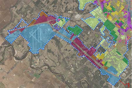
The City of Bryan has identified the Innovation Corridor as an area that, subsequent to very substantial public investment in infrastructure, will be ready for growth.

As envisioned within the last three comprehensive plans, it is reasonable to plan for and encourage high‐quality development featuring first‐class urban amenities and a connected transportation network along the IC.

The purpose of the IC zoning, and the accompanying overlay and development standards, is twofold:

  1. To ensure future development of urban amenities are on par with existing development on the anchor ends of the corridor.
  2. To promote the vision the city has described in previous plans.

The Innovation Corridor establishes high quality standards, allows for connectivity between parcels and prioritizes the preservation of the natural landscape.

Innovation Corridor Overview map

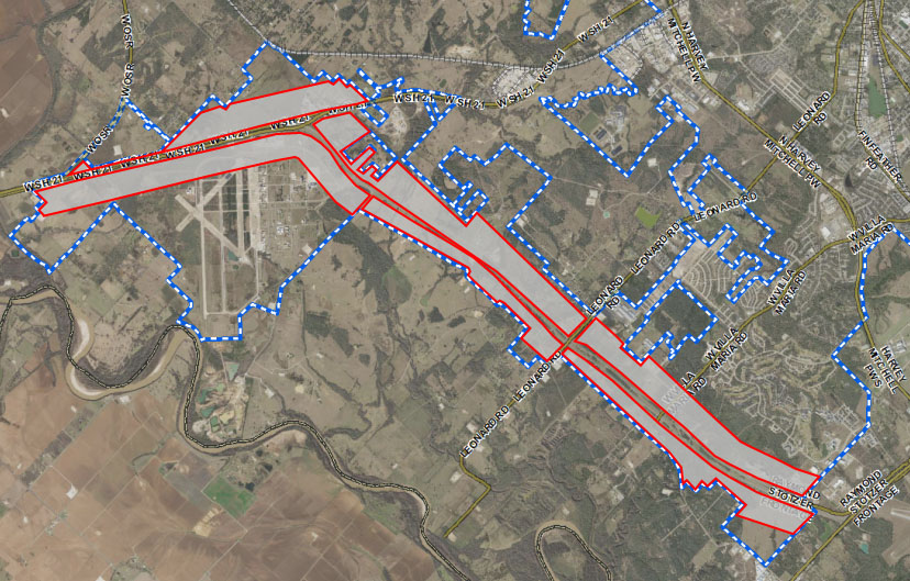
Hwy. 47: History of the Corridor

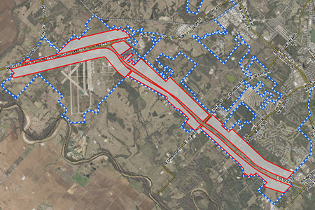
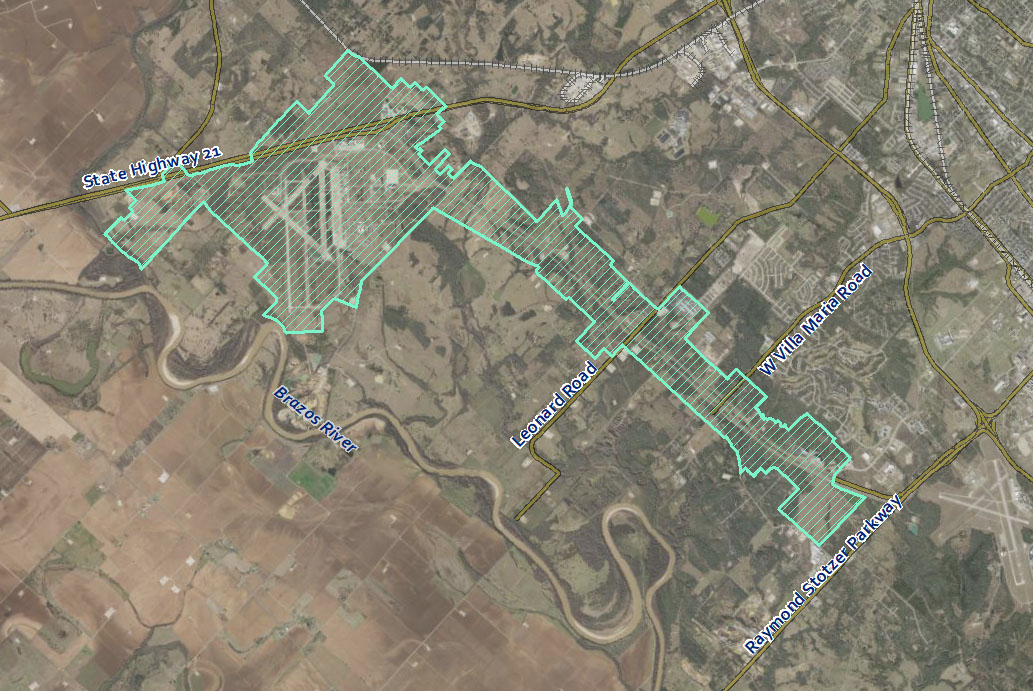
Started in 1987 and completed in August of 1996, State Highway 47 was a joint venture between the Texas Department of Transportation and Texas A&M University, to allow for a shortened route to the A&M campus for travelers coming from the west via State Highway 21. In the summer of 1999, the City of Bryan annexed State Highway 47 from the College Station city limits northwest to Old Goodson Bend Road.

This six‐mile long major thoroughfare now serves as the western‐most boundary for the City of Bryan and as soon as a number of long-term, very substantial public investments in infrastructure are complete, will be a premier market for development.

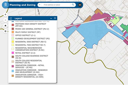
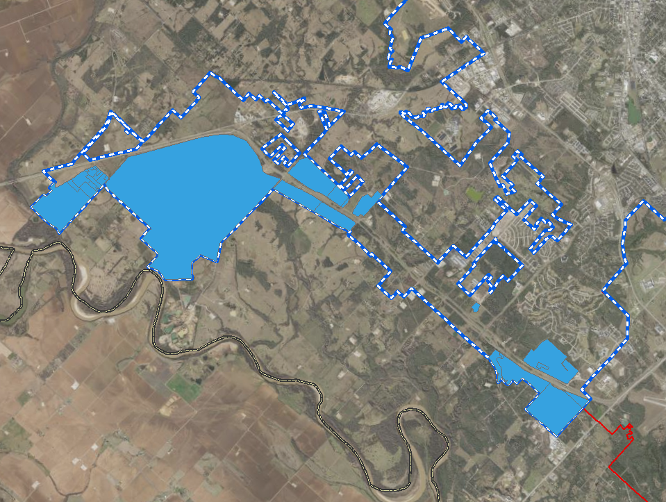
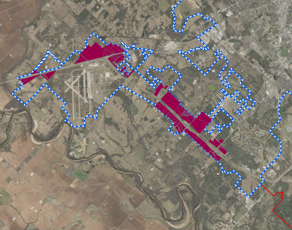
Innovation Corridor Zoning Districts


Research and Development District (IC‐RD)

The IC-RD, Innovation Corridor – Research and Development district is intended to be composed of offices and research buildings that support the RELLIS and Health and Sciences campus environments. Within the Innovation Corridor, these two innovative, collaborative, mixed-use campuses have been established and will continue to attract new commercial activity and enhance the City’s image as a desirable place to live work and shop within the State Highway 21 and 47 corridors.

RELLIS Campus builds upon, complements and supports the strengths of the A&M System and is on its way to becoming one of the nation’s leading “smart” collaborative innovation and research clusters. Buildings and structures in this district should strive for architectural compatibility with this existing private development while providing urban amenities and a connected transportation network.

innovation corridor: RD zoning map

Permitted uses

  • Accessory or incidental uses to the main use;
  • College or university support and auxiliary uses;
  • Conference center;
  • Eating and Drinking places (less than 5,000 sq. ft. gfa);
  • Essential municipal uses;
  • Finance, Insurance, and Real Estate establishments including banks, credit unions, real estate, and property management services;
  • Food stores;
  • Government (federal or state) owned structures, facilities, and uses;
  • Hotel (accessory to conference center);
  • Laboratories (scientific, medical, optical) and research facilities;
  • Medical facilities or clinics;
  • Museums and art galleries;
  • Offices for business, professional, and technical uses such as accountants, architects, lawyers, doctors, etc;
  • Parking, structured;
  • Place of worship;
  • Printing and publishing, book binding;
  • Schools, libraries, and community halls; and
  • Temporary structures for uses incidental to construction work on the premises, which said buildings shall be removed upon the completion or abandonment of construction work.

Conditional uses

  • Attached residential dwelling (townhome);
  • Childcare – Class C;
  • Detached residential dwellings on lots of at least one (1) acre;
  • Heliport or helistop;
  • Hotel (not accessory to conference center); and
  • Multifamily dwelling.

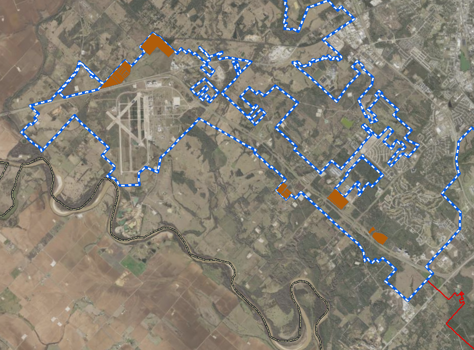
Retail Services District (IC‐RS)

The IC-RS, Innovation Corridor – Retail and Services district is established to provide locations for various types of general retail trade, business and service uses, but is not intended to be equated with the regional retail policies outlined by the Future Land Use Plan. The district allows shopping areas or uses which are generally compatible near or adjacent to, but not usually directly in, campus environments. Per the Southwest Bryan Highest and Best Use Study, this corridor could become the new connecting link among RELLIS, HSC and the main A&M Campus. In response, the corridor’s overall design concept should be elevated to the importance it holds in providing and enhancing the potential physical, social and aesthetic connections to TAMU campus sites and the City of Bryan. Industrial uses, for example, storage of raw materials, lumberyard or asphalt batching plant shall be prohibited.

Permitted uses

  • Accessory or incidental uses to the main use;
  • Apparel and accessory stores;
  • Child care – Class B;
  • Child care – Class C;
  • College or university support and auxiliary uses;
  • Commercial amusement (indoor);
  • Conference center;
  • Detached residential dwellings on lots of at least 0.5 acres;
  • Eating and Drinking places (less than 5,000 sq. ft. gfa);
  • Essential municipal uses;
  • Finance, Insurance, and Real Estate establishments including banks, credit unions, real estate, and property management services;
  • Fitness Center;
  • Food stores (less than 100,000 gfa);
  • Government (federal or state) owned structures, facilities, and uses;
  • Home furniture and furnishings and equipment stores;
  • Hotel;
  • Medical facilities or clinics;
  • Miscellaneous shopping goods stores;
  • Museums and art galleries;
  • Offices for business, professional, and technical uses such as accountants, architects, lawyers, doctors, etc;
  • Packaged liquor stores;
  • Parking, structured;
  • Personal service shop or custom personal services;
  • Place of worship;
  • Printing and publishing, book binding;
  • Retail or service, incidental;
  • Schools, libraries, and community halls;
  • Temporary structures for uses incidental to construction work on the premises, which said buildings shall be removed upon the completion or abandonment of construction work; and
  • Veterinary services (no outdoor runs or pens).

innovation corridor: RS zoning map

Conditional uses

  • Attached residential dwelling (townhome);
  • Automobile rental;
  • Detached residential dwellings on lots of at least one (1) acre;
  • Food stores (greater than 100,000 gfa);
  • Heliport or helistop;
  • Motor fuel retail (not accessory to a main use); and
  • Multifamily dwelling.

High‐Density Residential District (IC‐HDR)

The IC-HDR, Innovation Corridor – High-Density Residential district encourages high-density residential development and retail uses to support a residential community and preserve the established characteristic of the corridor. The district is intended to be composed of multi-story multifamily dwellings, condominiums, and townhouses. Per the Southwest Bryan Highest and Best Use Study, high-density residential developments shall contain at least 15 dwelling units per acre and shall provide flexibility for mixed-use development to occur seamlessly with surrounding retail and office development. Recreational, religious, health and educational uses normally located to service residential areas are also permitted in this district. A diverse range of housing products and density is necessary to support future mixed-use development along the corridor, consequently single detached dwelling units are discouraged on the corridor frontage.

innovation corridor: HDR zoning map

Permitted uses

  • Attached residential dwelling unit (townhome);
  • Detached residential dwellings on lots of at least 0.5 acres;
  • Essential municipal uses;
  • First-floor neighborhood services, subject to other regulations detailed in subsection (f) below;
  • Government owned structures, facilities, and uses;
  • Live/work units;
  • Multi-family dwelling unit and/or condominiums;
  • Parking, structured (accessory to primary residential use only);
  • Place of worship;
  • Schools, libraries, and community halls; and
  • Temporary structures for uses incidental to construction work on the premises, which said buildings shall be removed upon the completion or abandonment of construction work.

Conditional uses

  • Detached residential dwellings on lots of at least one (1) acre; and
  • Pied‐à‐terre;

Innovation Corridor Overlay District

An overlay district is a way for communities to apply area-specific standards or conditions on development. It creates a special zoning district, which is laid over the top of a base zoning district. The benefit of overlay districts is that they provide additional protection for defined areas and allow existing zoning regulations to be complemented in order to solve or prevent a threat to the success of the corridor.

An overlay district has been in effect for the State Highway 47 Corridor since 2002. The Innovation Corridor Overlay District expands on the existing boundary and regulations.

overlay district

This district is limited to specified areas encompassing land that has already been assigned conventional zoning district classifications. It supplements the standards of the underlying conventional districts with new or different standards, which may be more restrictive. These high-quality standards prioritize the preservation of the natural landscape while encouraging the development of high-quality urban amenities and a connected transportation network in order to ensure high-functioning growth and development along two major growth corridors (State Highway 47 and State Highway 21) in Bryan.

Still Have Questions?

For more information on the Innovation Corridor, please contact the Bryan Planning and Development Services Department at (979) 209-5030, or by email at planning@bryantx.gov.